


Complete Guide to Yosemite National Park Map: Your Essential Navigation Tool for 2025
Planning your Yosemite adventure? I've spent countless hours exploring this magnificent park and understand how crucial having the right yosemite national park map can be for a successful trip. Whether you're a first-time visitor or a seasoned hiker, this comprehensive guide will help you navigate Yosemite's 1,200 square miles of breathtaking wilderness with confidence. From official NPS maps to specialized topographic guides, I'll share everything you need to know about choosing and using the perfect map for your Yosemite experience. Visit Nature Guests for more outdoor adventure guides.
Understanding Yosemite National Park Maps
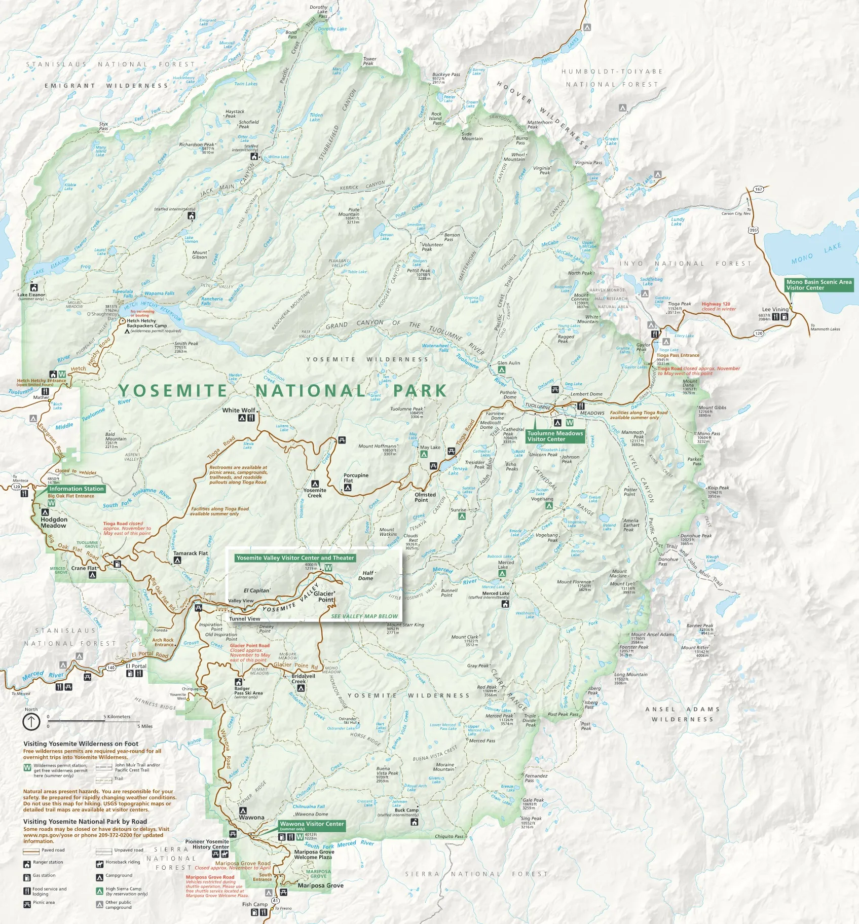
During my numerous visits to Yosemite, I've learned that having the right yosemite national park map is absolutely essential for both safety and maximizing your experience. Yosemite covers an impressive 1,200 square miles of diverse terrain, from the iconic Valley floor to the high country wilderness areas that remain snow-covered for much of the year.
The park's complex road system, seasonal closures, and vast network of trails make navigation challenging without proper mapping resources. I've witnessed countless visitors become disoriented simply because they relied solely on smartphone GPS, which often fails in Yosemite's remote areas due to limited cell coverage.
What makes a yosemite national park map truly valuable is its ability to show not just roads and trails, but also elevation changes, seasonal restrictions, and important safety information. The park rangers I've spoken with consistently emphasize that physical maps remain crucial backup navigation tools, even in our digital age.
Official Yosemite National Park Map - Essential for navigation
Why Physical Maps Matter in Yosemite
- Limited cell phone coverage in wilderness areas
- Battery-independent navigation backup
- Detailed topographic information for hiking
- Seasonal closure information clearly marked
Official Map Downloads & Resources
The National Park Service provides several official yosemite national park map options that I always recommend as your primary navigation resource. These maps are created and updated by park cartographers who understand the terrain intimately and include the most current information about road conditions, trail status, and safety considerations.
Official Park Map PDF
The comprehensive park-wide map showing all major roads, trails, and facilities. Perfect for trip planning and general navigation.
Yosemite Valley Detail Map
Focused map of the Valley area with detailed trail information, parking locations, and shuttle stops.
Important Map Updates & Considerations
Based on my experience and conversations with park rangers, always check for the most current version of any yosemite national park map before your visit. Road closures, especially on Tioga Pass Road and Glacier Point Road, can significantly impact your travel plans.
I recommend downloading maps directly from the official NPS website rather than relying on third-party sources, as these are updated most frequently with current conditions and safety information.
Essential Yosemite travel guide with navigation tips
Types of Yosemite Maps Available
Through years of hiking and exploring Yosemite, I've discovered that different activities require different types of maps. The standard yosemite national park map provided at entrance stations is excellent for general orientation, but specialized maps become essential for specific activities like backcountry hiking, rock climbing, or winter sports.
General Park Maps
NPS Unigrid Map
The classic National Park Service map with the iconic black header. I always grab several copies of these at the entrance station - they're perfect for planning and make great souvenirs.
Best for: General navigation, trip planning, first-time visitors
Yosemite Valley Special Map
A detailed focus on the Valley area showing shuttle routes, parking areas, and facilities. Essential for navigating the busy Valley floor efficiently.
Best for: Day visitors to the Valley, shuttle navigation
Specialized Maps
Topographic Trail Maps
Essential for serious hikers and backpackers. These show elevation contours, water sources, and detailed trail information that can be life-saving in the backcountry.
Best for: Backpacking, day hiking, wilderness exploration
Climbing Guidebooks
Detailed route maps for rock climbing areas including El Capitan and other popular climbing destinations. These are specialized publications beyond basic park maps.
Best for: Rock climbers, technical route planning
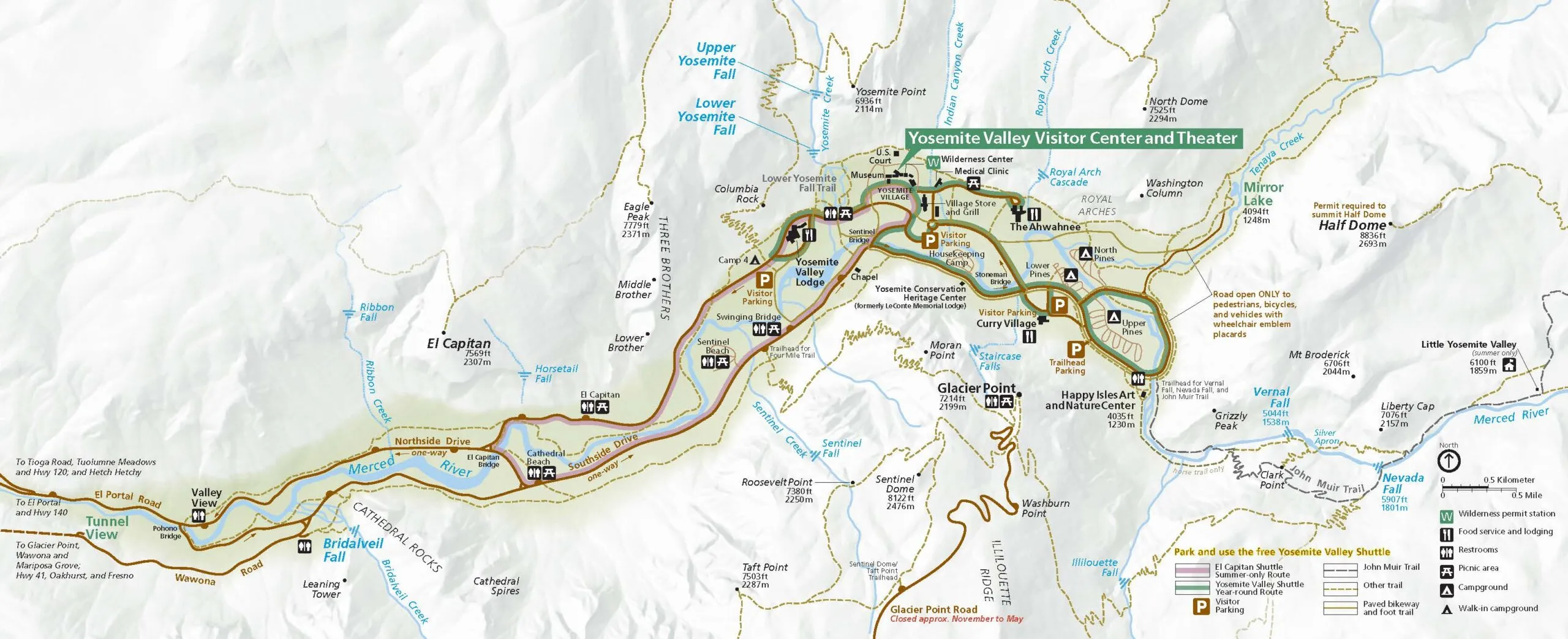
Detailed Yosemite Valley map for comprehensive navigation
Choosing the Right Map for Your Group
When I guide friends and family through Yosemite, I always consider their experience level and planned activities. For families with young children visiting Yosemite campgrounds, the standard park map is usually sufficient.
However, for those planning to stay in Yosemite cabins and explore backcountry areas, I always recommend investing in detailed topographic maps for safety and navigation accuracy.
Seasonal Map Considerations
One aspect of using a yosemite national park map that many visitors overlook is how dramatically the park changes throughout the year. I've learned through personal experience and ranger consultations that the same map can present entirely different navigation challenges depending on the season of your visit.
Winter Navigation (Nov-Apr)
- Tioga Pass Road completely closed
- Glacier Point Road closed beyond Badger Pass
- Chain requirements on most roads
Winter maps must account for limited access and snow conditions. I always check road status before winter trips.
Spring Navigation (May-Jun)
- Peak waterfall flow periods
- Tioga Pass may still be closed
- Most Valley trails accessible
Spring offers the best waterfall viewing but requires checking road opening status. Perfect for photographing Yosemite landscapes.
Summer Navigation (Jul-Sep)
- All roads and trails typically open
- Extreme crowds require early starts
- High country accessible for backpacking
Peak season means full access but also peak crowds. Your yosemite national park map becomes crucial for finding less crowded alternatives.
Fall Navigation (Oct-Nov)
- Reduced crowds and comfortable weather
- Early snow possible on high elevation roads
- Excellent conditions for hiking
Fall offers ideal conditions but requires monitoring weather changes that can affect high elevation access.
Seasonal Map Update Strategy
I've learned to always verify current conditions before relying on any yosemite national park map, regardless of how recent it appears. Park conditions change rapidly, especially during shoulder seasons when weather patterns are unpredictable.
The National Park Service website and visitor centers provide the most current information about road closures, trail conditions, and safety considerations that may not be reflected on older printed maps. For detailed planning resources, check our comprehensive Yosemite map guide.
Recommended Map Products
Throughout my years of exploring Yosemite, I've tested numerous map products and consulted with fellow hikers, park rangers, and outdoor gear specialists. These recommendations represent the most reliable and useful yosemite national park map products available, each serving specific needs and adventure types.
National Geographic Trails Illustrated Map
The gold standard for Yosemite navigation. Waterproof, tear-resistant, and incredibly detailed with topographic information.
- Waterproof and tear-resistant material
- Detailed topographic contours
- 4.7/5 stars from 498 reviews
Yosemite Day Hikes Map Guide
Perfect for day hikers with detailed trail descriptions and difficulty ratings. Includes timing estimates and elevation profiles.
- Detailed day hike descriptions
- Elevation profiles included
- 4.6/5 stars from 103 reviews
Yosemite Map Pack Bundle
Complete package with park overview map and detailed day hikes guide. The ultimate comprehensive solution.
- Both park and day hikes maps
- Comprehensive coverage
- 4.7/5 stars from 154 reviews
Best Easy Day Hiking Guide Bundle
Perfect for beginners and families. Includes easy trail recommendations with detailed descriptions and safety tips.
- Beginner-friendly trail selection
- Safety tips and guidelines
- 4.6/5 stars from 41 reviews
My Personal Recommendation Strategy
After years of guiding visitors through Yosemite, I typically recommend starting with the National Geographic Trails Illustrated map as your primary yosemite national park map. Its durability and detail level make it suitable for most visitors, from casual day hikers to serious backpackers.
For families or first-time visitors, adding the Day Hikes Map Guide provides excellent trail descriptions and difficulty ratings that help ensure a safe and enjoyable experience. The bundle options offer the best value for comprehensive trip planning.
Remember that investing in quality mapping resources is a small price to pay for the safety and enhanced experience they provide. A good map can mean the difference between a successful adventure and a dangerous situation in Yosemite's challenging terrain.
Conclusion
Throughout this comprehensive guide, I've shared the knowledge gained from countless hours exploring Yosemite's magnificent wilderness and consulting with park experts. A reliable yosemite national park map serves as more than just a navigation tool—it's your gateway to safe exploration, efficient trip planning, and discovering hidden gems throughout the park's 1,200 square miles of diverse terrain.
Whether you choose the official NPS maps for basic navigation, invest in specialized topographic guides for backcountry adventures, or opt for comprehensive bundles that cover all scenarios, the key is selecting mapping resources that match your experience level and planned activities. Remember that seasonal considerations can dramatically impact navigation requirements, making current, reliable maps absolutely essential for safety.
The investment in quality mapping resources is minimal compared to the enhanced safety, confidence, and overall experience they provide. As you plan your Yosemite adventure, prioritize obtaining the right yosemite national park map for your needs, study it thoroughly before your visit, and always carry backup navigation tools. With proper preparation and the guidance shared in this guide, you'll be equipped to explore Yosemite's wonders safely and confidently, creating memories that will last a lifetime.
Ready to Explore Yosemite?
Start planning your Yosemite adventure today with the perfect mapping resources and expert guidance.