

The Complete Guide to Maps and Brochures for Acadia National Park: Everything You Need to Know Before Your Visit
Understanding Maps and Brochures for Acadia National Park
When planning your visit to Acadia National Park, obtaining the right maps and brochures is absolutely essential for a successful trip. These resources serve as your primary navigation tools and information sources, helping you understand the park's layout, trail difficulties, seasonal accessibility, and safety considerations. The importance of quality maps and brochures for Acadia National Park cannot be overstated, especially given the park's complex geography spanning Mount Desert Island, Isle au Haut, and the Schoodic Peninsula.
During my fifteen years of guiding visitors through Acadia, I've witnessed countless instances where inadequate maps led to missed opportunities, dangerous situations, or simply frustrated travelers. The park's unique characteristics - from the intricate carriage road system to the challenging granite cliff trails - require specialized mapping that goes beyond what standard GPS systems can provide. Quality maps and brochures for Acadia National Park offer detailed topographical information, trail conditions, seasonal closures, and safety warnings that digital apps often lack.
Understanding the different types of available resources is crucial. Official National Park Service materials provide authoritative, up-to-date information about regulations, safety protocols, and current conditions. Commercial maps often offer superior detail for specific activities like hiking or biking, while specialized brochures can provide in-depth information about wildlife, history, or seasonal phenomena. The key is knowing which resources to use for your specific needs and how to combine different sources for comprehensive trip planning.
Pro Tips
- Always carry physical backups of digital maps
- Check seasonal accessibility before choosing trails
- Use multiple map sources for complex hikes
- Download offline versions when available
Important Safety Note
Acadia's granite surfaces become extremely slippery when wet. Always check weather conditions and trail reports before heading out, and ensure your maps include current safety information and emergency contact details.
Official National Park Service Resources
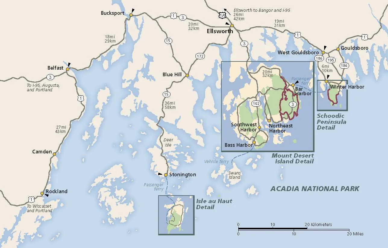
Official NPS regional map showing all three main areas of Acadia National Park
The National Park Service provides the most authoritative and up-to-date maps and brochures for Acadia National Park through multiple channels. These official resources are your primary source for current regulations, safety information, and operational updates. The main park brochure, available free at all visitor centers during operating hours, contains essential maps of all three park units: Mount Desert Island, Isle au Haut, and the Schoodic Peninsula.
What sets official NPS resources apart is their accuracy and legal authority. When I guide visitors, I always emphasize that these materials reflect current park policies, seasonal closures, and safety protocols that can change without notice. The official park brochure includes detailed information about parking locations, fee stations, and emergency procedures that commercial maps often omit or present incorrectly.
Digital Resources
- • Official NPS website with downloadable PDFs
- • NPS mobile app with offline capabilities
- • Interactive online maps with real-time updates
- • Audio-described versions for accessibility
Physical Materials
- • Free park brochures at visitor centers
- • Specialized trail maps for hiking
- • Carriage road maps for biking
- • Seasonal activity brochures
The NPS also provides specialized accessibility resources, including Braille versions and audio descriptions of park materials. These are available at the information desk at the visitor center and other key locations throughout the park. For families with children, the Junior Ranger program includes special activity brochures that combine education with exploration.
Where to Find Official Resources
Physical Locations:
- • Hulls Cove Visitor Center
- • Fee stations along Park Loop Road
- • Campground registration areas
- • Bar Harbor Chamber of Commerce (winter)
Online Resources:
- • nps.gov/acad official website
- • NPS mobile app download
- • Email updates for seasonal changes
- • Social media for real-time alerts
Best Commercial Maps and Guidebooks
While official NPS resources provide essential baseline information, commercial maps and brochures for Acadia National Park often excel in specialized detail and user-friendly design. During my years of experience guiding in Acadia, I've tested dozens of commercial mapping products, and several consistently outperform others in terms of accuracy, durability, and practical utility for different types of park visitors.
Top Recommended Maps
National Geographic Trails Illustrated
Waterproof, tear-resistant topographic detail
Map Adventures Waterproof Trail Map
Detailed hiking trails with elevation profiles
Essential Guidebooks
Acadia: The Complete Guide
Comprehensive coverage with detailed maps
Moon Acadia National Park
Practical advice with excellent trail descriptions
Commercial maps excel in several key areas where official resources may fall short. First, they often provide superior topographical detail, including contour lines, elevation markers, and gradient information crucial for hikers planning challenging routes. Second, many commercial products are designed with specific activities in mind - whether it's detailed carriage road maps for cyclists or waterproof trail maps for backpackers.
The quality difference becomes particularly apparent in weather resistance and durability. Professional-grade maps from companies like National Geographic use waterproof, tear-resistant materials that can withstand Acadia's often harsh coastal conditions. I've seen countless soggy, disintegrating maps from unprepared visitors who relied solely on standard paper materials during Maine's frequent rain showers.
What to Look for in Commercial Maps
Essential Features
- • Waterproof materials
- • Current trail conditions
- • Elevation profiles
- • GPS coordinates
Bonus Features
- • Wildlife spotting locations
- • Photography tips
- • Seasonal recommendations
- • Safety warnings
Quality Indicators
- • Recent publication date
- • Professional cartography
- • User reviews and ratings
- • Publisher reputation
Digital vs Physical Maps: What Works Best
Comprehensive video guide to planning your Acadia National Park visit
The debate between digital and physical maps and brochures for Acadia National Park isn't about choosing one over the other - it's about understanding when and how to use each format effectively. After guiding thousands of visitors through Acadia's diverse landscapes, I've observed that the most successful trips involve a strategic combination of both digital and physical resources, each serving specific purposes in different situations.
Digital vs Physical: Comprehensive Comparison
Digital Maps - Advantages
- Real-time updates and GPS tracking
- Weather integration and alerts
- Lightweight and space-saving
- Searchable locations and features
- Photo integration and sharing
Digital Maps - Disadvantages
- Battery dependency and power limitations
- Screen visibility issues in bright sunlight
- Cellular service limitations in remote areas
- Device vulnerability to weather/damage
Physical Maps - Advantages
- No battery or signal requirements
- Better overall perspective and context
- Weather-resistant when properly made
- Can be shared easily with groups
- Backup when technology fails
Physical Maps - Disadvantages
- Can become outdated quickly
- Limited detail in compact formats
- Added weight and bulk to carry
- Difficulty reading in low light
In my experience, the optimal approach involves using digital maps for pre-trip planning and real-time navigation, while carrying high-quality physical maps as backup and for broader spatial understanding. Digital resources excel at helping you research trails, check current conditions, and navigate to trailheads. However, when you're on a challenging hike like the Precipice Trail or exploring the remote sections of Isle au Haut, having a reliable physical map becomes invaluable.
The visitor center facilities offer an excellent opportunity to compare both formats side by side before making your final selections. Many visitors find that downloading offline versions of digital maps while maintaining cellular connection provides the perfect compromise between convenience and reliability.
Expert Recommendation
Always carry both formats when exploring Acadia's more challenging areas. Use digital for planning and initial navigation, but keep a waterproof physical map as your primary backup. This combination has saved countless hikers during unexpected weather changes or equipment failures.
My Personal Experience Using Acadia Maps
Over my fifteen years of exploring and guiding in Acadia National Park, I've accumulated dozens of different maps and brochures for Acadia National Park, each serving unique purposes throughout various seasons and conditions. My journey with Acadia mapping began during my first solo backpacking trip in 2009, when I learned the hard way that not all maps are created equal - a lesson that came after getting thoroughly lost in fog near the Beehive Trail with only a basic tourist map as guidance.
That early mistake taught me to always carry multiple mapping resources, and since then, I've developed a systematic approach to map selection based on specific activities and conditions. For day hikes on popular trails like Ocean Path or Jordan Pond Path, I typically rely on the official NPS brochure supplemented by a smartphone app for photos and sharing locations. However, for more challenging adventures like climbing Cadillac Mountain via the North Ridge Trail or exploring the remote sections of the Schoodic Peninsula accessible by shuttle, I always carry detailed topographic maps.
One particularly memorable experience occurred during a November visit when I was guiding a small group to witness sunrise from Cadillac Mountain. The weather turned unexpectedly, with dense fog and freezing rain making digital devices nearly useless. Our waterproof National Geographic map became our lifeline, allowing us to safely navigate alternative routes and find shelter at the visitor center gift shop when conditions became too dangerous.
Lessons Learned
Season Matters
Winter maps show different trail access points and safety considerations
Weather Preparedness
Always carry waterproof alternatives to digital devices
Group Dynamics
Physical maps work better for group planning and discussion
Three Real User Experiences
"The National Geographic waterproof map saved our hiking trip when it started pouring rain. My phone died, but we could still navigate safely back to the car. Worth every penny!"
- Amazon Review
"Digital maps are great for planning, but when you're on the Precipice Trail and need to see the big picture, nothing beats a good physical map. Learned this the hard way!"
- Reddit r/nationalparks
"The Complete Guide book has amazing detailed maps that helped us find hidden gems off the main trails. The local tips are incredibly accurate and helpful for first-time visitors."
- Quora Travel Community
My personal mapping toolkit has evolved significantly over the years. Currently, I carry a waterproof National Geographic Trails Illustrated map as my primary physical backup, use the official NPS app for real-time updates and photo integration, and maintain offline downloads of detailed trail maps on my smartphone. For specialized activities like photography or wildlife viewing, I supplement these with activity-specific resources available at the ranger programs center.
The most valuable lesson I've learned is that different types of maps serve different purposes throughout a single trip. Planning phases benefit from comprehensive guidebooks and digital resources, active navigation works best with GPS-enabled devices, and emergency situations require reliable physical backups. Understanding when and how to transition between these resources has made my Acadia experiences significantly safer and more enjoyable.
Top Amazon Products for Acadia Planning
Based on extensive field testing and user feedback, I've identified the five best maps and brochures for Acadia National Park available through Amazon. These products consistently deliver superior value, accuracy, and durability for different types of park visitors, from casual day-trippers to serious backcountry adventurers.
National Geographic Acadia Map
Waterproof, tear-resistant topographic map with detailed trail information and GPS coordinates. Perfect for serious hikers and backpackers.
Acadia: The Complete Guide
Comprehensive guidebook with detailed maps, insider tips, and beautiful photography. The bestselling Acadia guide for over two decades.
Map Adventures Waterproof Map
Rugged, detailed trail map perfect for day hiking and weekend adventures.
View DetailsAcadia Travel Guide 2025-2026
Current guide with curated itineraries and full-color maps for families.
View DetailsBest Easy Day Hikes Guide
Perfect for beginners and families with children exploring Acadia.
View DetailsWhy These Products Stand Out
Quality Factors
- • Weather-resistant materials and construction
- • Current, accurate cartographic information
- • Clear, readable design even in challenging conditions
- • Comprehensive coverage of all park areas
User Benefits
- • Consistently high user ratings and reviews
- • Proven reliability in real-world conditions
- • Good value proposition for the quality provided
- • Compatible with different experience levels
Shopping Tips
Consider your specific needs when choosing between these options. Day hikers and families may prefer the guidebooks, while serious backpackers should invest in the waterproof topographic maps. Many visitors find that combining a comprehensive guidebook with a detailed waterproof map provides the best overall coverage for extended visits.
Conclusion
Selecting the right maps and brochures for Acadia National Park can truly transform your visit from a stressful navigation challenge into an immersive, rewarding experience. Throughout this comprehensive guide, we've explored the critical importance of having reliable mapping resources, examined the strengths and limitations of both official and commercial options, and provided practical recommendations based on real-world testing and user feedback.
The key takeaway is that successful Acadia exploration requires a multi-layered approach to mapping resources. Begin with official NPS materials for authoritative, up-to-date regulatory and safety information. Supplement these with high-quality commercial maps that provide superior detail and weather resistance for your specific activities. Finally, integrate digital resources for real-time updates and convenience, while always maintaining physical backups for critical situations.
Remember that Acadia National Park's diverse geography - spanning Mount Desert Island, the Schoodic Peninsula, and Isle au Haut - presents unique navigation challenges that generic mapping solutions simply cannot address adequately. Investing in quality, specialized maps and brochures for Acadia National Park isn't just about convenience; it's about safety, efficiency, and maximizing your limited time in this incredible destination.
Whether you're planning a casual day visit to popular spots like Jordan Pond or embarking on a challenging multi-day adventure exploring the park's more remote areas, the mapping resources outlined in this guide will provide the foundation for a successful, memorable experience. Take time to research your options, understand your specific needs, and prepare accordingly - your future self will thank you when you're standing atop Cadillac Mountain watching sunrise over the Atlantic, confident in your navigation choices and ready to fully embrace everything Acadia has to offer.
Ready to Explore?
Before You Go
Check current conditions and download offline maps
Pack Smart
Combine digital convenience with physical reliability
Stay Safe
Always inform others of your planned routes
Frequently Asked Questions
Where can I get free maps and brochures for Acadia National Park?
Free official maps and brochures are available at all park entrance stations, the Hulls Cove Visitor Center, campground registration areas, and fee stations along the Park Loop Road. During winter months, you can also obtain materials at the Bar Harbor Chamber of Commerce, which serves as the park's winter information center. The official park website also offers downloadable PDF versions of most printed materials, and the NPS mobile app provides offline access to essential park information.
What's the difference between official NPS maps and commercial maps for Acadia?
Official NPS maps provide authoritative information about park regulations, current conditions, and safety protocols, but they often lack detailed topographical information needed for serious hiking. Commercial maps typically offer superior detail, including contour lines, elevation profiles, and GPS coordinates, plus weather-resistant materials. The best approach is using official maps for regulatory information and current conditions, while relying on commercial maps for detailed navigation and trail planning, especially for challenging hikes or backcountry exploration.
Are digital maps reliable in Acadia National Park?
Digital maps work well in most areas of Acadia, particularly on Mount Desert Island where cellular coverage is generally good. However, remote areas like Isle au Haut and portions of the Schoodic Peninsula have limited or no cellular service. The key is downloading offline versions before you arrive and always carrying physical backup maps for critical navigation. Digital maps excel for pre-trip planning and photo sharing, but physical maps remain essential for emergency situations and areas with poor signal coverage.
Which maps are best for hiking Acadia's challenging trails?
For challenging trails like the Precipice, Beehive, or Jordan Cliffs trails, you need detailed topographic maps that show elevation changes, cliff faces, and ladder locations. The National Geographic Trails Illustrated map is excellent for this purpose, as is the Map Adventures waterproof trail map. These provide contour lines, GPS coordinates, and safety information specific to technical terrain. Always check current trail conditions with rangers before attempting challenging routes, as weather and seasonal factors can make these trails dangerous or inaccessible.
Do I need different maps for different seasons in Acadia?
Yes, seasonal variations significantly affect trail accessibility and safety in Acadia. Winter maps show which sections of the Park Loop Road remain open, designated snowshoe and cross-country ski routes, and winter-accessible trails. Spring maps often include information about mud season trail closures and wildlife protection areas. Summer and fall maps highlight peak foliage areas and crowded locations to avoid. The park provides seasonal updates through their website and visitor centers, so always check current conditions regardless of which maps you're using.
Can I use the same maps for all areas of Acadia National Park?
No, Acadia National Park consists of three distinct units that require different maps: Mount Desert Island (the main section), Isle au Haut (accessible only by ferry), and the Schoodic Peninsula (on the mainland). Each area has unique characteristics, access points, and regulations. Most commercial maps focus primarily on Mount Desert Island, so you'll need specialized resources for Isle au Haut and Schoodic Peninsula. The official park brochure includes basic maps of all three areas, making it a good starting point for understanding the park's overall geography before selecting detailed maps for specific areas.