


Complete Guide to Reading Hiking Trail Maps: Master Navigation Skills for Safe Adventures
Master the essential skill of reading hiking trail maps with this comprehensive guide. I'll share practical techniques, personal field experiences, and expert tips to help you navigate confidently through any terrain while staying safe on the trails.
Understanding Different Types of Trail Maps
When I first started hiking in the White Mountains of New Hampshire, I made the mistake of assuming all trail maps were created equal. After getting turned around on a poorly marked trail with nothing but a basic park brochure, I learned that understanding the different types of maps available is crucial for successful navigation. Reading hiking trail maps effectively begins with choosing the right type of map for your specific adventure.
Topographic maps, often called "topo maps," are the gold standard for serious hikers. These detailed representations show elevation changes through contour lines, making them indispensable for understanding terrain difficulty. During my recent backpacking trip through Glacier National Park, the USGS topographic maps helped me identify a gradual ascent route that avoided steep switchbacks, saving hours of strenuous climbing.
Trail-specific maps, produced by organizations like National Geographic or local hiking clubs, focus specifically on marked trails and popular destinations. These maps excel at showing trail junctions, campsites, and points of interest. I've found them particularly valuable in places like the Appalachian Trail, where clear trail blazing information can prevent costly navigation errors.
Digital maps through apps like AllTrails or Gaia GPS offer real-time location tracking and can work offline when properly downloaded. However, reading hiking trail maps on digital devices requires understanding their limitations – screen glare in bright sunlight, battery dependence, and sometimes less detailed topographic information than printed versions.
Park service maps serve as excellent supplementary resources, providing current trail conditions, seasonal closures, and safety information. These maps often include valuable context about water sources, permit requirements, and emergency procedures that aren't found on standard topographic maps. The key to successful navigation is combining multiple map types to create a comprehensive understanding of your hiking environment.Essential Map Features and Symbols
Mastering the art of reading hiking trail maps requires fluency in the language of cartographic symbols. During my years of leading hiking groups through various terrains, I've observed that most navigation errors stem from misinterpreting basic map symbols rather than complex route-finding challenges.
The legend, typically located in a corner of your map, serves as your translation guide. On a memorable solo hike through the Olympic Peninsula, I initially confused a jeep road symbol with a hiking trail, leading to an unexpected three-mile detour on a gravel road. This experience taught me to always consult the legend before setting out, no matter how familiar I think I am with the area.
Scale indicators tell you the relationship between map distance and real-world distance. Most hiking maps use scales like 1:24,000 or 1:50,000, meaning one inch on the map equals 24,000 or 50,000 inches in reality. Understanding scale is crucial for time estimation – a skill I developed during my thru-hike attempt on the Pacific Crest Trail, where accurate distance calculation meant the difference between making camp and hiking in darkness.
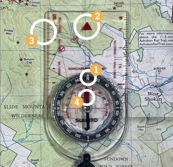
North arrows and declination information ensure proper compass orientation. Magnetic declination varies by location and changes over time, making this information critical for accurate bearing work. In the Colorado Rockies, where I frequently guide hiking groups, the declination difference can throw off navigation by several degrees if not properly accounted for.
Water features appear in blue and include streams, lakes, springs, and wetlands. These landmarks serve as excellent navigation references and crucial resources for backcountry camping. Elevation markers, shown as specific points with height above sea level, help confirm your location and track climbing progress. Understanding these fundamental elements transforms reading hiking trail maps from guesswork into precise navigation science.
Reading Contour Lines and Topography
Contour lines represent the soul of topographic navigation, yet they remain the most intimidating aspect of reading hiking trail maps for many outdoor enthusiasts. My breakthrough in understanding contours came during a challenging ascent of Mount Washington, where the tight spacing of lines on my map perfectly predicted the grueling switchbacks awaiting me on the Tuckerman Ravine trail.
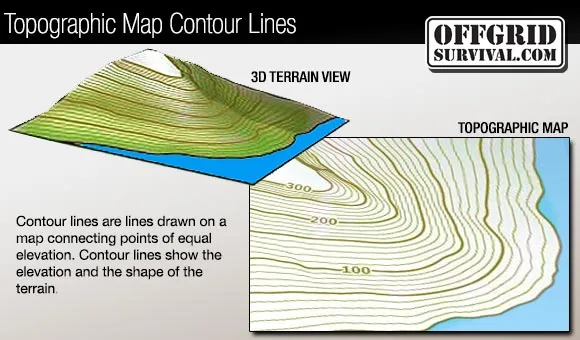
Each contour line connects points of equal elevation, creating a two-dimensional representation of three-dimensional terrain. The spacing between lines reveals slope steepness – closely packed lines indicate steep terrain, while widely spaced lines suggest gentle slopes. On a recent hike through Utah's Zion National Park, I used this principle to identify a more gradual approach to Angels Landing, avoiding the notoriously steep sections that had challenged me on previous visits.
Index lines, typically every fifth contour and marked with elevation numbers, provide reference points for tracking your ascent or descent. During my winter hiking in the Adirondacks, these index lines became crucial for monitoring our elevation gain when snow obscured familiar landmarks. Understanding that most hiking maps use 10, 20, or 40-foot contour intervals helps estimate the vertical challenge ahead.
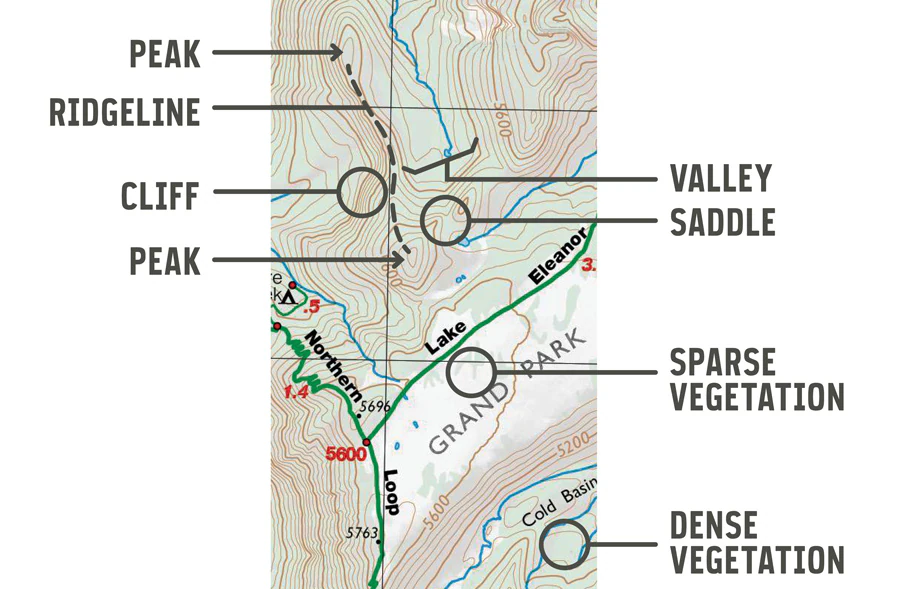
Topographic features reveal themselves through contour patterns. Ridges appear as elongated areas where contours form parallel lines, while valleys create V-shaped patterns pointing uphill. Saddles show up as hourglass formations, and peaks appear as concentric circles. Learning to visualize these three-dimensional shapes from two-dimensional lines transforms reading hiking trail maps into an intuitive skill.
Practical application involves comparing contour patterns with actual terrain as you hike. I make it a habit to stop at viewpoints and correlate what I see with the contour representation on my map. This practice, developed over countless hiking miles from the Smoky Mountains to the Sierra Nevada, builds the mental mapping skills essential for confident backcountry navigation.
Digital vs Paper Maps: When to Use Each
The debate between digital and paper maps reflects a broader conversation about technology's role in outdoor recreation. Through extensive field testing across diverse environments, from desert canyons to alpine peaks, I've learned that mastering reading hiking trail maps requires understanding the strengths and limitations of both formats.
Digital maps excel in convenience and real-time information. GPS-enabled devices show your exact position, eliminating guesswork about current location. During my recent section hike of the Continental Divide Trail, smartphone apps like Gaia GPS provided invaluable trail condition updates from other hikers, water source reliability, and weather integration that paper maps simply cannot match.
However, digital dependence carries significant risks in backcountry environments. Cold weather dramatically reduces battery life – a lesson learned during a winter camping trip in Wyoming's Wind River Range where my phone died within hours despite starting with full charge. Screen glare makes digital displays nearly impossible to read in bright sunlight, and touchscreen functionality fails with wet hands or while wearing gloves.
Paper maps provide reliability and comprehensive terrain visualization that digital screens cannot replicate. The ability to spread out a full topographic map and trace routes with your finger creates spatial awareness that small phone screens fragment. During multi-day backpacking trips, I can study paper maps around the campfire without worrying about battery conservation, planning routes and identifying alternate options for changing weather conditions.
Professional Recommendation
I recommend a hybrid approach: use digital maps for real-time navigation and current information, but always carry paper maps as backup. This redundancy has saved countless hiking adventures when technology fails at critical moments.
The optimal strategy combines both formats strategically. Digital tools handle route planning, track recording, and sharing with emergency contacts, while paper maps provide the big-picture perspective essential for route modification and emergency navigation. This approach to reading hiking trail maps acknowledges that technology enhances but never replaces fundamental navigation skills.
Common Mistakes and Safety Considerations
Navigation errors in the backcountry can transform enjoyable hiking adventures into dangerous survival situations. My experience teaching wilderness navigation has revealed consistent patterns in how hikers make mistakes when reading hiking trail maps, often with preventable consequences that proper preparation could have avoided.
Over-reliance on trails marked on maps without considering current conditions represents the most common navigation error I encounter. Maps may show trails that have been abandoned, rerouted, or become impassable due to weather events. During a group hike in Vermont's Green Mountains, following an outdated trail marking led us to a washout where the bridge had been removed years earlier, requiring a significant backtrack and route revision.
Ignoring declination when using compass bearings with maps creates systematic errors that compound with distance. In the Pacific Northwest, where magnetic declination exceeds 15 degrees, this oversight can lead hikers miles off course. I always adjust my compass for local declination and verify the adjustment date, as declination changes over time and varies significantly by geographic location.
Critical Safety Warning
Always inform someone of your planned route and expected return time. Carry emergency communication devices in remote areas, and know how to signal for help if navigation errors lead to genuine emergencies.
Misreading scale leads to dangerous time and distance miscalculations. What appears to be a short hike on a small-scale overview map may actually involve significant elevation gain and technical terrain requiring much more time than anticipated. I've learned to calculate hiking time using both horizontal distance and vertical gain, accounting for terrain difficulty and weather conditions.
Failure to continuously check position against the map while hiking allows small errors to become major problems. I advocate for frequent position checks at identifiable landmarks – trail junctions, stream crossings, distinctive topographic features – rather than walking for hours without confirming location. This habit of constant cross-referencing prevents the navigation errors that turn routine hikes into emergency situations.
Conclusion
Mastering the skill of reading hiking trail maps transforms outdoor adventures from chance encounters with nature into confident explorations of wild places. Through decades of hiking experience across diverse terrains, I've learned that navigation competency provides the foundation for safe, enjoyable backcountry travel that opens doors to remote destinations most hikers never experience.
The techniques and principles covered in this guide represent essential knowledge that every serious hiker should develop through practice and field application. Reading hiking trail maps effectively requires more than theoretical understanding – it demands hands-on experience, repeated practice, and the confidence that comes from successfully navigating challenging terrain using map and compass skills.
Technology will continue evolving, offering new tools and capabilities for outdoor navigation, but the fundamental skills of reading hiking trail maps remain timeless. These abilities provide backup when technology fails, enhance spatial awareness in any environment, and connect us more deeply with the landscapes we explore. Whether you're planning your first day hike or preparing for a multi-week wilderness expedition, investing time in developing solid navigation skills pays dividends in safety, confidence, and access to extraordinary outdoor experiences.
Start with familiar trails close to home, practice with different map types and scales, and gradually build complexity as your skills develop. Remember that every expert navigator started as a beginner, and even experienced hikers continue learning with each adventure. The mountains, forests, and wild places are waiting – let your newly developed map-reading skills guide you safely to extraordinary destinations.